
Vanguard 1: Fifty Years Later

Requirement: 1) place a satellite in orbit during the IGY; 2) accomplish a scientific experiment in orbit; 3) track the satellite and ensure its attainment of orbit. Because of an ongoing classified program to put reconnaissance satellites in orbit (Project WS-117 using Air Force Thor MRBM’s – which later became the Korona-series of reconnaissance satellites), preference was for a civilian-derived booster and payload. In August 1955, the DOD Committee on Special Capabilities chose the Navy’s proposal as it appeared most likely to be able to place a satellite in orbit by spring 1958.
Designated Project Vanguard, the program was placed under Navy management and DoD monitorship. The Naval Research Laboratory (NRL) in Washington was given overall responsibility, while funding came from the National Science Foundation. The director was John P. Hagen (1908–1990), an astronomer who in 1958 would become the assistant director of space flight development with the formation of NASA. NRL was also responsible for developing the launch vehicles, developing and installing the satellite tracking system, and designing, constructing, and testing the satellites. The tracking system was called Minitrack – Minitrack stations, designed, built, and initially operated by NRL, were placed on a North-South line running along the east coast of North America and the west coast of South America. Minitrack was the forerunner of another NRL-developed system called NAVSPASUR, which remains operational today under the control of the Air Force and is a major producer of spacecraft tracking data.
Spacecraft and Subsystems
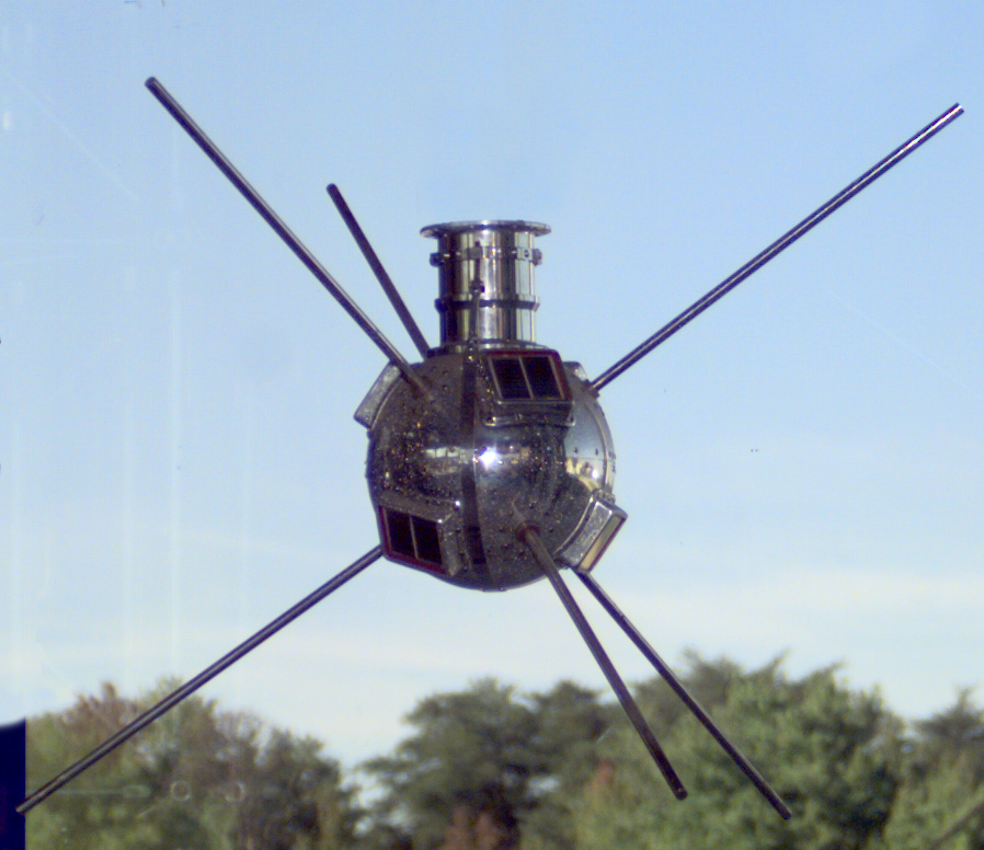
The spacecraft was a 1.47-kg aluminum sphere 16.5 cm in diameter. It contained a 10-mW, 108-MHz mercury-battery powered transmitter and a 5-mW, 108.03-MHz transmitter powered by six square (roughly 5 cm on a side) solar cells mounted on the body of the satellite. Six 30 cm aerials protruded from the sphere. The transmitters were used primarily for engineering and tracking data, but were also used to determine the total electron content between the satellite and ground stations. Vanguard also carried two thermistors which measured the interior temperature over 16 days in order to track the effectiveness of the thermal protection.
Booster
The Vanguard rocket was designed as a three-stage vehicle. The first stage was a General Electric y-405 liquid-fueled engine (designated XLR50-GE-2 by the Navy), derived from the engine of the RTV-N-12a Viking. The second stage was the Aerojet General AJ10-37 (XLR52-AJ-2) liquid-fueled engine, a variant of the engine in the RTV-N-10 Aerobee. Finally, the third stage was a solid-propellant rocket motor. All three-stage Vanguard flights except the last one used a motor built by the Grand Central Rocket Company. Vanguard had no fins, and the first and second stages were controlled by gimballed nozzles. The second stage also housed the vehicle’s telemetry system, the inertial guidance system and the autopilot. The third stage was spin stabilized, the spin being imparted by a turn-table on the second stage before separation.
Mission Profile
The three stage launch vehicle placed Vanguard into a 654 x 3969 km 134.2 minute orbit inclined at 34.25 degrees. Original estimates had the orbit lasting for 2000 years, but it was discovered that solar radiation pressure and atmospheric drag during high levels of solar activity produced significant perturbations in the perigee height of the satellite, which caused a significant decrease in its expected lifetime to only about 240 years. The battery powered transmitter stopped operating in June 1958 when the batteries ran down. The solar powered transmitter operated until May 1964 (when the last signals were received in Quito, Ecuador) after which the spacecraft was optically tracked from Earth.
Although Vanguard was the fourth vehicle to be orbited (following Sputniks 1 and 2 and Explorer 1) it has far outlived it predecessors and remains to this day, the longest lived manmade object still on orbit.
—–
_____
References:
NASA: http://nssdc.gsfc.nasa.gov/nmc/spacecraftDisplay.do?id=1958-002B
Naval History Center: Naval Aviation Chronology: 1954-1959
Naval Research Laboratory: Pushing the Horizon: 75 years of High Stakes Science and Technology at the Naval Research Laboratory
Wikipedia: Vanguard 1

Great stuff! Love that video.
b2
Does anyone have any info on the Army Map Service and Naval Research Laboratory “Project Betty” that was a secondary Vanguard tracking project for accurately mapping distant geographic locations in relation to each other? The initial tracking site was at Ft. Belvoir, VA. Other sites were on Pacific Islands.